Loading Data
Find USDA Eligible Properties in Worcester County
 browse list of realtors working in Worcester County
Worcester county has 5 usdaproperties.com realtors ready to help with your search!
| April Featured Agents | |
|---|---|
| Michelle Fermin | from Century 21 Northest - The Fermin Group |
| Mati Alcantara | from Remax One |
| Lauren Mace | from Neylon Real Estate |
| John Keefe | from Results Realty |
| Michael Blood | from Blood Team Realty Group |
Looking to buy in Worcester County, Massachusetts?
There are 1,941 USDA backed residential loans in Worcester county with an average loan balance of $179,081. Over 85% of the loans helped first time home buyers. Borrowers were an average age of 37 years old. The typical appraised home value was around $179,668. On average the rural home size purchased with this loan was approximately 1,381 SqFt. Alternate income limits exist to determine loan eligibility in Worcester county. For a household of upto 4 people the income limit is $111,100. For a household of between 5 and 8 people the income limit increases to $146,650.
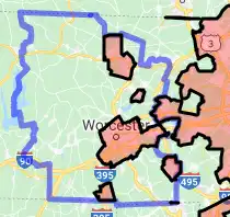
The size of Worcester County is roughly 4,090 square kilometers. USDA defined regions of rural loan ineligibility in Worcester cover 589 square kilometers of the county. Approximately 14.4% of Worcester County is ineligible for traditional USDA home loans. The influence score for Worcester County is 1. Look below for the interactive county level map illustration below for more details.
Select from the list of cities below or use the search feature to find active property listings in a city where you would like to live.
Start your search for USDA loan eligible properties in the cities of Worcester County, MA ![]()
* cities most likely to have USDA loan eligible properties for sale.
*Ashburnham • *Athol • Auburn • Bakers Grove • *Baldwinville • *Barre • Barre Falls • Barre Plains • Belmont Hill • *Berlin • Beverly Road • Blackburn Village • *Blackstone • *Bolton • *Boylston • Boylston Center • Bramanville • *Brookfield • Brooks • Brooks Village • Buffumville • Bullardville • Camp Barton • Camp Bement • Camp Caravan • Camp Collier • Camp Green Eyrie • Camp Kinneywood • Camp Neyati • Camp Resolute • Camp Virginia • Canada Mills • Carterville • Centerville • Chaffinville • Chapinville • *Charlton • Charlton City • Charlton Depot • Chaseville • Cherry Valley • Chestnut Hill Meeting House • Clinton • Coldbrook Springs • Colonial Park • Cominsville • Community Park • *Cordaville • Dana Center • Dawson • *Devens • Dodge • Dorothy Manor • Dorothy Pond • *Douglas • Drury Square • *Dudley • Eaglesville • East Berlin • East Blackstone • East Bolton • *East Brookfield • *East Douglas • East Douglas Station • East Millbury • East Princeton • East Sutton • East Templeton • Ebenville • Edgemere • Farnumsville • Fayville • Fennerville • Fisherville • *Fiskdale • Fitchburg • Fryeville • *Gardner • Gates Crossing • Gilbertville • Glen Grove • Glen Grove Annex • Glen Heights • Glenallen • Globe Village • Goodrichville • Goulding Village • Grafton • Greenville • Halfway House • *Hardwick • Harrisville • *Harvard • Harvard Station • Heald Village • Heard Street • Hillsville • Hodges Village • *Holden • Holden Center • Hopedale • *Hubbardston • Hubbardston Station • Hundred Acre Lot • Hydeville • Island • Jefferson • June Street • Kittville • Lakewood Park • Lambs Grove • *Lancaster • Lane Village • *Leicester • Leino Park • Leominster • Linwood • Lovellville • Lower Wire Village • *Lunenburg • Lunenburg Station • Manchaug • Mantyranta • Maplewood • Marions Camp • Marks Garrison • Massasoit • *Mendon • Milford • Mill Street • Mill Village • Millbury • Millerville • *Millville • Morningdale • Morseville • Muschopauge • Mystic Grove • Neale Place • *New Braintree • New Village • Nichewaug • North Ashburnham • *North Brookfield • North Grafton • North Milford • North Oxford • North Rutland • North Spencer • North Uxbridge • North Village • North Woods • *Northborough • *Northbridge • Northbridge Center • Northside • Oak Hill • Oakdale • *Oakham • Oakland Heights • Old Common • Old North Ashburnham Station • Old Sturbridge Village • Otter River • *Oxford • Oxford Heights • Pakachoag • Parkers Station • Partridgeville • *Paxton • Pequoig • Perryville • *Petersham • *Phillipston • Pinecrest • Pinedale • Pitcherville • Pleasant Valley • Ponakin Mill • Pondville • *Princeton • Princeton Station • Proctors Corner • Quinapoxet • Riverdale • Robinson Crusoe Camp • Rochdale • Rocky Hill • *Royalston • Ruralville • *Rutland • Sandersdale • Sandy Beach • Saundersville • Shaker Village • Shrewsbury • Shrewsbury Street • Smithville • *South Ashburnham • South Athol • South Barre • South Berlin • South Bolton • South Charlton • South Grafton Street • *South Lancaster • South Milford • South Royalston • South Shrewsbury • South Spencer • South Sutton • *Southborough • Southbridge • *Southbridge Town • Southville • *Spencer • Spindleville • *Sterling • Sterling Camp Grounds • Still River • *Sturbridge • Sunnyside • *Sutton • Swan Avenue • Tasseltop • *Templeton • Templeton Station • Texas • The Street • Turkey Hill Shores • Union Chapel • Unionville • Upper Wire Village • *Upton • *Uxbridge • Vernon Hill • Wachusett Station • *Warren • Waterville • Wawela Park • Webster • Wellville • Wessonville • West Auburn • West Berlin • *West Boylston • *West Brookfield • West Dudley • West Millbury • West Oxford • West Royalston • West Rutland • West Sterling • West Sutton • West Upton • West Warren • Westborough • *Westminster • Westville • Westwood Hills • Whalom • Wheelockville • Wheelwright • White City • White Hall • White Valley • *Whitinsville • Whitmanville • Wilkinsonville • *Winchendon • Winchendon Springs • Woodland Park • Woodside • Worcester
A USDA loan is a mortgage option available to eligible homebuyers that is sponsored by the United States Department of Agriculture to promote homeownership in rural communities. USDA Loans, sometimes called "RD Loans," offer 100% financing options on eligible rural properties. USDAProperties can help you find USDA properties in Worcester County.
View the detailed USDA boundaries and read about general conditions of
Worcester County, Massachusetts
 .
.Worcester County is a county located in the central region of the state of Massachusetts. It was officially founded on April 2, 1731, making it one of the oldest counties in the Commonwealth of Massachusetts. The county was named after Worcester, England, from where many early settlers originated.
The region's history goes back even further when it was home to various Native American tribes, including the Nipmuc and Mohegan tribes. European exploration began in the 17th century, with prominent settlers such as John Eliot and Moses Rice establishing communities in the area.
During the 18th and 19th centuries, Worcester County played a pivotal role in the American Revolutionary War and the Industrial Revolution. The city of Worcester, the county seat, was an important manufacturing center and transportation hub for the entire New England region. Additionally, Worcester County was known for its role in the American abolitionist movement, with many residents embracing the cause and taking part in the Underground Railroad.
Throughout the 20th century, Worcester County continued to be an economic powerhouse, with manufacturing, trade, and education as the main driving forces. The county boasts numerous prestigious colleges and universities, such as Worcester Polytechnic Institute, Clark University, and the College of the Holy Cross.
One fun fact about Worcester County is that it is home to the birthplace of the smiley face, invented by Worcester native Harvey Ball in 1963. This iconic symbol has transcended international boundaries and is now a universal symbol for happiness and positivity.
Featured Cities of Massachusetts


