Loading Data
Find USDA Eligible Properties in Somerset County
 browse list of realtors working in Somerset County
Somerset county has 1 usdaproperties.com realtor ready to help with your search!
| April Featured Agent | |
|---|---|
| Stanley Russell | from Realty of Maine |
Looking to buy in Somerset County, Maine?
There are 732 USDA backed residential loans in Somerset county with an average loan balance of $88,599. Over 80% of the loans helped first time home buyers. Borrowers were an average age of 38 years old. The typical appraised home value was around $96,744. On average the rural home size purchased with this loan was approximately 1,345 SqFt. Somerset county applies the standard USDA income limits to determine loan eligibility. For a household of upto 4 people the income limit is $90,300. For a household of between 5 and 8 people the income limit is increased to $119,200.
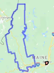
The size of Somerset County is roughly 10,599 square kilometers. There are no geographical USDA loan restrictions in this county. The influence score for Somerset County is 8. Look below for the interactive county level map illustration below for more details.
Select from the list of cities below or use the search feature to find active property listings in a city where you would like to live.
Start your search for USDA loan eligible properties in the cities of Somerset County, ME ![]()
* cities most likely to have USDA loan eligible properties for sale.
*Anson • *Athens • *Bingham • Blair • Brassua • *Brighton • *Cambridge • *Canaan • *Caratunk • Castle Harmony • *Cornville • Cyrs • Deadwater • *Dennistown • *Detroit • Dogtown • Dyerville • East Madison • East Mercer • East New Portland • *Embden • *Fairfield • Fairfield Center • *Harmony • *Hartland • *Highland • Hinckley • Holeb • Hoxies • *Jackman • La Croix Depot • Lake Moxie • Lakewood • Larone • Long Pond • Lower Mill • Mackamp • *Madison • Mainstream • Malbons Mills • *Mercer • *Moose River • *Moscow • *New Portland • *Norridgewock • North Anson • North Fairfield • North New Portland • Ogontz • *Palmyra • *Pittsfield • Pleasant Pond • *Pleasant Ridge • Poplar Ripps • *Ripley • Rockwood • Saint Albans • Seboomook • Shawmut • *Skowhegan • *Smithfield • *Solon • South Solon • Spring Lake • *Starks • Stronghold • Tarratine • *The Forks • Thompson • Three Streams • Troutdale • Waltons Mill • Waverley • West Athens • *West Forks • West Palmyra • Wildwood
A USDA loan is a mortgage option available to eligible homebuyers that is sponsored by the United States Department of Agriculture to promote homeownership in rural communities. USDA Loans, sometimes called "RD Loans," offer 100% financing options on eligible rural properties. USDAProperties can help you find USDA properties in Somerset County.
View the detailed USDA boundaries and read about general conditions of
Somerset County, Maine
 .
.Somerset County, located in the great state of Maine, encompasses a rich and varied history, dating back thousands of years. It was initially inhabited by Native American tribes, such as the Abenaki, who referred to the region's waterways, like the Kennebec River, as "Norridgewock," meaning "the quiet and swift-running water place."
European settlers first arrived in the early 17th century, primarily from England and France. The area was part of the larger Massachusetts Bay Colony and saw frequent land disputes between the British and French empires. The conflicts came to an end with the 1763 Treaty of Paris, and the region became part of the United States post the Revolutionary War.
Somerset County was established on March 1, 1809, with an area of approximately 4,095 square miles, making it the third-largest county in Maine. Named after Somerset Street in Boston, Somerset County originally encompassed present-day Franklin and Piscataquis Counties before they were separated in 1838 and 1839, respectively.
The development of industry in the region centered around agriculture and lumber production. Sawmills and gristmills became prominent features of the local economy, leveraging the Kennebec River's power for energy. The arrival of the railroad in the mid-19th century connected Somerset County to broader markets and bolstered its economy.
A fun fact about Somerset County is that it's home to the Arnold Trail, a historic route taken by Benedict Arnold during the Revolutionary War in 1775. Arnold led 1,100 troops from Cambridge, Massachusetts, to Quebec City, Canada hoping to capture the city. The trail remains a testament to this strategic yet ultimately unsuccessful campaign. Today, Somerset County maintains its rural appeal and offers numerous recreational opportunities like hiking, fishing, and snowmobiling.
Featured Cities of Maine


