Loading Data
USDA Eligibility Boundaries for Clay, Minnesota 

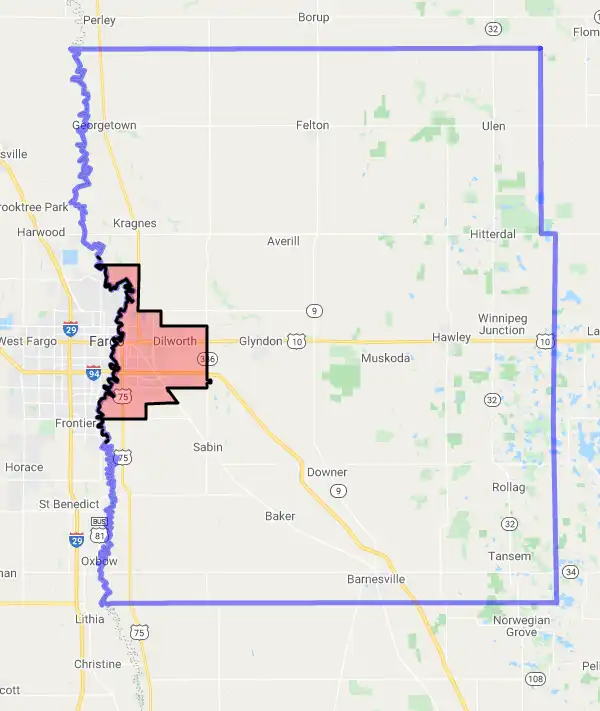
92.8% of Clay County is eligible for a USDA home loan.
The United States Department of Agriculture has rated the natural amenities of this region. On a scale of one to seven, Clay county is rated a 2. The average temperature during the month of June is 70.7℉ and the average temperature in January is 5.9℉. The typical humidity of this area is approximately 53% and the area covered by water is 0.71%. The overall influence score for Clay is 2.
The map below displays geographic boundaries of Clay, Minnesota with a blue border. Regions of Minnesota that are highlighted in red are not eligible for USDA backed home loan programs in the state of Minnesota. Typically these red-highlighted restricted areas represent areas of denser population areas such as city centers. USDAProperties.com can help you determine exactly what properties for sale are outside these exclusionary boundary areas. For higher resolution imagery click the map to zoom in or search for specific postal (zip) codes, city names or even counties. You can also search for specific addresses using the power search feature here.
Select from the above list of cities in Clay County. Cities most likely to have USDA loan eligible properties are highlighted in the drop down list. Alternatively, use the search form to find your favorite counties, cities and zip codes in Minnesota.
Clay County is located in the northwest region of Minnesota. It has a population of 64,967 and a population density of 24.5 people per square mile. The county seat is Moorhead.
The majority of Clay County's population is white (90.3%), followed by Hispanic or Latino (4.6%), Native American (1.7%), Asian (1.4%), and African American (1.2%). The median household income in Clay County is $55,838 and the median home value is $186,400.
The average climate in Clay County is cold and windy with long, snowy winters and warm, humid summers. The area experiences an average of 33 inches of snow per year with temperatures ranging from -18 to 88 degrees Fahrenheit.
Clay County has a variety of housing options including single-family homes, townhomes, condominiums, mobile homes, and apartments. The cost of living index in Clay County is above the national average due to higher housing costs, but lower than the state average overall.
Overall, Clay County offers its residents a safe, affordable place to live with access to many amenities such as golf courses, parks, lakes, shopping centers, restaurants, and other recreational activities.
Clay, Minnesota

Loan officers and realtors can answer your questions about USDA home loan programs.
For direct assistance with Minnesota USDA program details you can also contact:
USDA Rural Development State Office:Featured Property from USDA Loan Eligible Regions of Minnesota
375 Jackson Street | Suite 410
St. Paul, MN 55101
(651) 602-7800
