Loading Data
USDA Eligibility Boundaries for Otero, New Mexico 

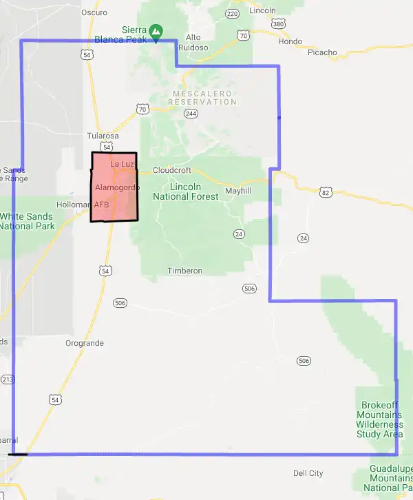
97.5% of Otero County is eligible for a USDA home loan.
The United States Department of Agriculture has rated the natural amenities of this region. On a scale of one to seven, Otero county is rated a 5. The average temperature during the month of June is 80.6℉ and the average temperature in January is 39.3℉. The typical humidity of this area is approximately 29% and the area covered by water is 0.01%. The overall influence score for Otero is 5.
The map below displays geographic boundaries of Otero, New Mexico with a blue border. Regions of New Mexico that are highlighted in red are not eligible for USDA backed home loan programs in the state of New Mexico. Typically these red-highlighted restricted areas represent areas of denser population areas such as city centers. USDAProperties.com can help you determine exactly what properties for sale are outside these exclusionary boundary areas. For higher resolution imagery click the map to zoom in or search for specific postal (zip) codes, city names or even counties. You can also search for specific addresses using the power search feature here.
Select from the above list of cities in Otero County. Cities most likely to have USDA loan eligible properties are highlighted in the drop down list. Alternatively, use the search form to find your favorite counties, cities and zip codes in New Mexico.
Otero County is located in the southeastern corner of New Mexico and is bordered by Texas to the east, Arizona to the south, and Chihuahua in Mexico to the south. According to the 2019 U.S. Census, Otero County has a population of 68,857 people, of which 51.6% are White, 35.6% are Hispanic or Latino, 5.4% are American Indian or Alaska Native, 2.3% are Asian, 0.7% are Black or African American, and 3.4% are two or more races. The median household income for Otero County is $42,793 and 19.5% of residents live below the poverty line.
Living conditions in Otero County vary between rural and urban areas. The majority of the county is rural and there are very few towns or cities with populations over 10,000 people. The largest city in Otero County is Alamogordo with a population of 32,403 as of 2019. Other smaller towns include Cloudcroft (population 817), Tularosa (population 2,660), and La Luz (population 683). The county also contains several military installations such as White Sands Missile Range and Holloman Air Force Base.
The climate in Otero County is generally dry and arid with hot summers and mild winters. The area receives little rainfall and temperatures can reach up to 100 degrees Fahrenheit (37 degrees Celsius) during summer months.
Otero, New Mexico
Loan officers and realtors can answer your questions about USDA home loan programs.
For direct assistance with New Mexico USDA program details you can also contact:
USDA Rural Development State OfficeFeatured Property from USDA Loan Eligible Regions of New Mexico
100 Sun Avenue NE, Suite 130
Albuquerque, NM 87109
Phone: 505-761-4950
