Loading Data
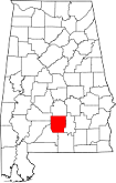
USDA Eligibility Boundaries for Butler, Alabama 

There are no geographical USDA loan restrictions in this county. 100% of Butler County is eligible for rural development USDA home loans.
The United States Department of Agriculture has rated the natural amenities of this region. On a scale of one to seven, Butler county is rated a 3. The average temperature during the month of June is 80.8℉ and the average temperature in January is 49.2℉. The typical humidity of this area is approximately 69% and the area covered by water is 0.13%. The overall influence score for Butler is 8.
The map below displays geographic boundaries of Butler, Alabama with a blue border. There are no significant USDA regional restrictions in this county. For higher resolution imagery click the map to zoom in or search for specific postal (zip) codes, city names or even counties. You can also search for specific addresses using the power search feature here.
Select from the above list of cities in Butler County. Cities most likely to have USDA loan eligible properties are highlighted in the drop down list. Alternatively, use the search form to find your favorite counties, cities and zip codes in Alabama.

Butler County, Alabama is located in the southeastern part of the state and has a population of 19,500. The population is predominantly African American, making up over 70% of the county's population. The median household income is $27,899, which is lower than the national average. Nearly a quarter of the population lives below the poverty line.
The living conditions in Butler County are generally rural and agricultural. It is home to several small towns and unincorporated communities with limited access to healthcare, education and other services. The area also has issues with unemployment and crime.
Butler, Alabama

Loan officers and realtors can answer your questions about USDA home loan programs.
For direct assistance with Alabama USDA program details you can also contact:
USDA RURAL DEVELOPMENT STATE OFFICEFeatured Property from USDA Loan Eligible Regions of Alabama
4121 Carmichael Road, Suite 601
Montgomery, AL 36106
334-279-3400
Alabama USDA Rural Development programs are administered through 8 Area Offices. For information or to file an application, contact the Area Office serving your county.