Loading Data
USDA Eligibility Boundaries for Edwards, Illinois 

There are no geographical USDA loan restrictions in this county. 100% of Edwards County is eligible for rural development USDA home loans.
The United States Department of Agriculture has rated the natural amenities of this region. On a scale of one to seven, Edwards county is rated a 2. The average temperature during the month of June is 77.2℉ and the average temperature in January is 32.7℉. The typical humidity of this area is approximately 59% and the area covered by water is 0.13%. The overall influence score for Edwards is 9.
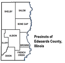
The map below displays geographic boundaries of Edwards, Illinois with a blue border. There are no significant USDA regional restrictions in this county. For higher resolution imagery click the map to zoom in or search for specific postal (zip) codes, city names or even counties. You can also search for specific addresses using the power search feature here.
Select from the above list of cities in Edwards County. Cities most likely to have USDA loan eligible properties are highlighted in the drop down list. Alternatively, use the search form to find your favorite counties, cities and zip codes in Illinois.

Edwards County is located in southwestern Illinois and is part of the Illinois/Indiana/Kentucky tri-state area. As of the 2010 census, the population was 6,721. The county seat is Albion.
The demographics of Edwards County show that the majority of its population is white (97.1%), with a small minority of African Americans (0.3%) and Hispanic/Latinos (1.3%). The median household income in Edwards County is $45,945 and the poverty rate is 17.8%.
Living conditions in Edwards County are generally rural and there are few large cities or towns within its borders. The county is mostly agricultural, with numerous farms and small towns dotted across the landscape. The largest town in Edwards County is Albion, which has a population of about 1,500. Other towns include Grayville, Bone Gap, and West Salem.
Edwards, Illinois

Loan officers and realtors can answer your questions about USDA home loan programs.
For direct assistance with Illinois USDA program details you can also contact:
Illinois State Office USDA Rural DevelopmentFeatured Property from USDA Loan Eligible Regions of Illinois
2118 West Park Court, Suite A
Champaign, IL 61821
TEL: 217-403-6200
TTY: 217-403-6240