Loading Data
Find USDA Eligible Properties in Wayne County
 browse list of realtors working in Wayne County
Wayne county has 5 usdaproperties.com realtors ready to help with your search!
| July 2024 Featured Agents | |
|---|---|
| Tammy Stevens | from Weichert Realtors Ford Brothers |
| Jay Craig | from United Country Lakes and Land Realty |
Looking to buy in Wayne County, Kentucky?
There are 128 USDA backed residential loans in Wayne county with an average loan balance of $78,977. Over 82% of the loans helped first time home buyers. Borrowers were an average age of 39 years old. The typical appraised home value was around $81,830. On average the rural home size purchased with this loan was approximately 1,337 SqFt. Wayne county applies the standard USDA income limits to determine loan eligibility. For a household of upto 4 people the income limit is $90,300. For a household of between 5 and 8 people the income limit is increased to $119,200.
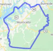
The size of Wayne County is roughly 1,253 square kilometers. There are no geographical USDA loan restrictions in this county. The influence score for Wayne County is 8. Look below for the interactive county level map illustration below for more details.
Select from the list of cities below or use the search feature to find active property listings in a city where you would like to live.
Start your search for USDA loan eligible properties in the cities of Wayne County, KY ![]()
* cities most likely to have USDA loan eligible properties for sale.
Barrier • Bethesda • Betsey • Burfield • Cabell • Cooper • Coopersville • Delta • Denney • Eadsville • Frazer • Frisby • Gapcreek • Gregory • Griffin • Hardwick • Hidalgo • Kidder • Kidds Crossing • Low Gap • Mill Springs • *Monticello • Mount Pisgah • Murl • Number One • Oil Valley • Oilton • Parmleysville • Parnell • Powersburg • Pueblo • Ramsey Island • Rankin • Ritner • Rockybranch • Sandclift • Shearer Valley • Short Mountain • Slat • Slickford • Spann • Steubenville • Sumpter • Sunnybrook • Susie • Swifton • Touristville • Wait • Windy • Wray Gap • Zula
A USDA loan is a mortgage option available to eligible homebuyers that is sponsored by the United States Department of Agriculture to promote homeownership in rural communities. USDA Loans, sometimes called "RD Loans," offer 100% financing options on eligible rural properties. USDAProperties can help you find USDA properties in Wayne County.
View the detailed USDA boundaries and read about general conditions of
Wayne County, Kentucky
 .
.Wayne County, located in the great state of Kentucky, was established on December 13, 1800, by an act of the Kentucky General Assembly. The county was named after General "Mad" Anthony Wayne, a prominent figure in the American Revolutionary War and the Northwest Indian War. Its county seat is Monticello, named after Thomas Jefferson's famous Virginia home.
The region that is now present-day Wayne County was originally inhabited by Native American tribes, primarily Cherokee, and later by settlers who came in search of a better life. Early settlers faced hardship due to its isolated and hilly terrain, but they managed to establish productive communities, embracing agriculture and trade.
Lumber production, coal mining, and manufacturing boomed in Wayne County during the late 19th and early 20th centuries. The Tennessee Valley Authority (TVA) constructed Wolf Creek Dam, which resulted in the creation of Lake Cumberland in 1951, flooding much of the county and sacrificing fertile farming land. While the lake led to a decline in agriculture, it gave way to an increase in tourism and recreation.
A fun fact about Wayne County: It is home to one of the largest waterfalls in Kentucky, the Yahoo Falls, which has a 113-foot drop. The region is popular for its breathtaking natural scenery, attracting hikers, photographers, and outdoor enthusiasts.
Featured Cities of Kentucky


