Loading Data
USDA Eligibility Boundaries for Buchanan, Missouri 


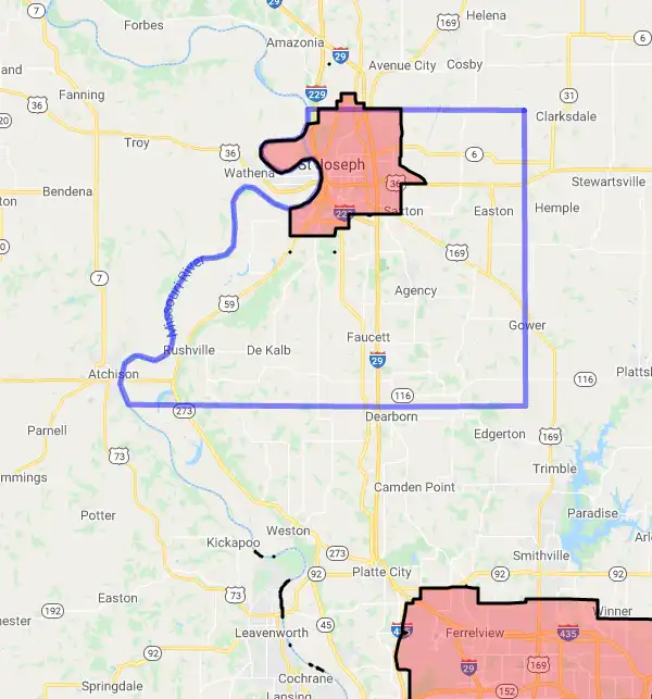
87.0% of Buchanan County is eligible for a USDA home loan.
The United States Department of Agriculture has rated the natural amenities of this region. On a scale of one to seven, Buchanan county is rated a 3. The average temperature during the month of June is 78.2℉ and the average temperature in January is 26.2℉. The typical humidity of this area is approximately 53% and the area covered by water is 1.17%. The overall influence score for Buchanan is 2.
The map below displays geographic boundaries of Buchanan, Missouri with a blue border. Regions of Missouri that are highlighted in red are not eligible for USDA backed home loan programs in the state of Missouri. Typically these red-highlighted restricted areas represent areas of denser population areas such as city centers. USDAProperties.com can help you determine exactly what properties for sale are outside these exclusionary boundary areas. For higher resolution imagery click the map to zoom in or search for specific postal (zip) codes, city names or even counties. You can also search for specific addresses using the power search feature here.
Select from the above list of cities in Buchanan County. Cities most likely to have USDA loan eligible properties are highlighted in the drop down list. Alternatively, use the search form to find your favorite counties, cities and zip codes in Missouri.

Buchanan County is located in the northwest corner of Missouri and covers an area of 583 square miles. As of 2019, the population of Buchanan County was 87,541, with a population density of 150 people per square mile. The median household income for the county was $43,839, and the median age was 39.4 years old.
The majority of Buchanan County residents are white (86.3%), followed by African American (7.2%), Hispanic or Latino (3.3%), and Asian (1.2%). The largest cities in the county are St. Joseph (76,780) and Savannah (3,807). The majority of Buchanan County residents are employed in manufacturing (20.9%), health care and social assistance (14.1%), retail trade (13.4%), and educational services (12.4%).
Buchanan County has a mix of rural and suburban living conditions. The county is home to several small towns, such as DeKalb and Agency, as well as larger cities like St. Joseph and Savannah. The housing stock consists mainly of single-family homes, though there are some apartments and other multi-family dwellings available in the larger towns and cities. The median value of owner-occupied homes in the county is $118,400.
Overall, Buchanan County is a safe and affordable place to live with plenty of job opportunities and recreational activities available in the surrounding areas.
Buchanan, Missouri

Loan officers and realtors can answer your questions about USDA home loan programs.
For direct assistance with Missouri USDA program details you can also contact:
The Missouri State Office is located at:Featured Property from USDA Loan Eligible Regions of Missouri
601 Business Loop 70 West
Parkade Center, Suite 235
Columbia, MO 65203
Phone: (573) 876-0976
Our staff is available to assist you from 8:00 am to 4:30 pm Monday through Friday. Please contact us for assistance.

