Loading Data
Find USDA Eligible Properties in Catron County
 browse list of realtors working in Catron County
Catron county has 1 usdaproperties.com realtor ready to help with your search!
| July 2024 Featured Agent | |
|---|---|
| Eric Krueger | from New Mexico West Properties |
Looking to buy in Catron County, New Mexico?
Select from the list of cities below or use the search feature to find active property listings in a city where you would like to live.
Start your search for USDA loan eligible properties in the cities of Catron County, NM ![]()
* cities most likely to have USDA loan eligible properties for sale.
Alma • *Apache Creek • *Aragon • Aspen Mountain • Cooney • *Cruzville • *Datil • *Escudilla Bonita • *Glenwood • Gutierrezville • *Homestead • Lehew • Lower Frisco • *Luna • Mangas • *Middle Frisco • Mogollon • Old Horse Springs • Omega • *Pie Town • *Pleasanton • Potato Patch • *Quemado • *Rancho Grande • Red Hill • *Reserve • Rivers • Salt Lake • San Francisco Plaza • Spur Lake • Tres Lagunas • Webster Place • Wilcox Peak
A USDA loan is a mortgage option available to eligible homebuyers that is sponsored by the United States Department of Agriculture to promote homeownership in rural communities. USDA Loans, sometimes called "RD Loans," offer 100% financing options on eligible rural properties. USDAProperties can help you find USDA properties in Catron County.
View the detailed USDA boundaries and read about general conditions of
Catron County, New Mexico
 .
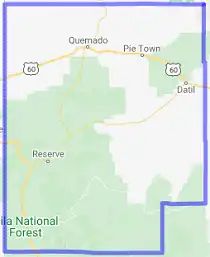
.Catron County is located in the southwestern region of the great state of New Mexico, USA. Established on February 25, 1921, the county was named after Thomas Benton Catron, a prominent lawyer, and politician from New Mexico. It was formed by carving out parts of Socorro and Apache counties, making it the largest county in New Mexico, occupying an area of around 7,000 square miles.
Before the arrival of European settlers, the area was inhabited by various Native American tribes, including the Mogollon, whose remnants can be seen at the Gila Cliff Dwellings, and the Ancestral Puebloans. The region was under Spanish control from the late 1500s and subsequently became a part of Mexico after its independence from Spain in 1821. Following the Mexican-American War and the Treaty of Guadalupe Hidalgo in 1848, most of modern-day New Mexico, including Catron County, came under the jurisdiction of the United States.
The economy of Catron County has primarily revolved around ranching, logging, and mining throughout its history, with cattle ranches and timber operations still defining the county's landscape. Today, the area is also known for its exquisite natural attractions, which include the Gila National Forest, the Gila Wilderness, and the Apache National Forest, among others.
Fun fact: Catron County is home to the "Lightning Field," an iconic land art installation created by artist Walter De Maria in 1977. It consists of 400 stainless steel poles arranged in a grid measuring one mile by one kilometer, intended to attract lightning strikes in the high desert during thunderstorms, creating a fascinating display of natural and man-made artistry.
Featured Cities of New Mexico


