Loading Data
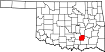
USDA Eligibility Boundaries for Coal, Oklahoma 

There are no geographical USDA loan restrictions in this county. 100% of Coal County is eligible for rural development USDA home loans.
The United States Department of Agriculture has rated the natural amenities of this region. On a scale of one to seven, Coal county is rated a 4. The average temperature during the month of June is 82.6℉ and the average temperature in January is 40.9℉. The typical humidity of this area is approximately 38% and the area covered by water is 0.59%. The overall influence score for Coal is 9.
The map below displays geographic boundaries of Coal, Oklahoma with a blue border. There are no significant USDA regional restrictions in this county. For higher resolution imagery click the map to zoom in or search for specific postal (zip) codes, city names or even counties. You can also search for specific addresses using the power search feature here.
Select from the above list of cities in Coal County. Cities most likely to have USDA loan eligible properties are highlighted in the drop down list. Alternatively, use the search form to find your favorite counties, cities and zip codes in Oklahoma.

Coal County is located in the southeastern corner of Oklahoma and borders Texas and Arkansas. As of 2019, the population of Coal County was 8,719. The median age of residents is 38.8 years, and the median household income is $36,919.
The majority of the population is white (84%), followed by Native American (13%), Hispanic (2%), and African-American (1%). Approximately 41% of Coal County households have children under the age of 18.
Living conditions in Coal County are relatively sparse. The area has a higher than average poverty rate, with 20.4% of the population living below the poverty line. Unemployment is also higher than average at 6.2%.
The county is home to several small towns, including Lehigh, Coalgate, Centrahoma, Tupelo, and Clarita. The county seat is Coalgate. The main industries in Coal County are agriculture and energy production, with coal mining and oil drilling being the primary sources of employment.
Coal, Oklahoma

Loan officers and realtors can answer your questions about USDA home loan programs.
For direct assistance with Oklahoma USDA program details you can also contact:
Oklahoma Rural Development State OfficeFeatured Property from USDA Loan Eligible Regions of Oklahoma
100 USDA Suite 108
Stillwater, OK 74074
1 (800) 522-3819
Fax: 1 (855) 423-4043