Loading Data
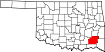
USDA Eligibility Boundaries for Pushmataha, Oklahoma 

There are no geographical USDA loan restrictions in this county. 100% of Pushmataha County is eligible for rural development USDA home loans.
The United States Department of Agriculture has rated the natural amenities of this region. On a scale of one to seven, Pushmataha county is rated a 4. The average temperature during the month of June is 82.1℉ and the average temperature in January is 41.8℉. The typical humidity of this area is approximately 51% and the area covered by water is 1.79%. The overall influence score for Pushmataha is 8.
The map below displays geographic boundaries of Pushmataha, Oklahoma with a blue border. There are no significant USDA regional restrictions in this county. For higher resolution imagery click the map to zoom in or search for specific postal (zip) codes, city names or even counties. You can also search for specific addresses using the power search feature here.
Select from the above list of cities in Pushmataha County. Cities most likely to have USDA loan eligible properties are highlighted in the drop down list. Alternatively, use the search form to find your favorite counties, cities and zip codes in Oklahoma.

Pushmataha County is located in southeastern Oklahoma and is part of the Choctaw Nation. According to the 2010 census, the population of Pushmataha County was 11,572. The population is largely Native American (47.2%) and White (48.3%). The median household income is $30,735, and the median home value is $66,800.
Living conditions in Pushmataha County are relatively rural and sparsely populated. The county is largely comprised of agricultural and forestry land, with the majority of people living in small towns or rural areas. There is a lack of access to healthcare and other services due to the county's remote location. There is also limited access to education, with only one public school district serving the entire county.
Pushmataha, Oklahoma

Loan officers and realtors can answer your questions about USDA home loan programs.
For direct assistance with Oklahoma USDA program details you can also contact:
Oklahoma Rural Development State OfficeFeatured Property from USDA Loan Eligible Regions of Oklahoma
100 USDA Suite 108
Stillwater, OK 74074
1 (800) 522-3819
Fax: 1 (855) 423-4043