Loading Data
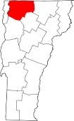
USDA Eligibility Boundaries for Franklin, Vermont 

There are no geographical USDA loan restrictions in this county. 100% of Franklin County is eligible for rural development USDA home loans.
The United States Department of Agriculture has rated the natural amenities of this region. On a scale of one to seven, Franklin county is rated a 3. The average temperature during the month of June is 70.3℉ and the average temperature in January is 16.8℉. The typical humidity of this area is approximately 64% and the area covered by water is 8.02%. The overall influence score for Franklin is 2.
The map below displays geographic boundaries of Franklin, Vermont with a blue border. There are no significant USDA regional restrictions in this county. For higher resolution imagery click the map to zoom in or search for specific postal (zip) codes, city names or even counties. You can also search for specific addresses using the power search feature here.
Select from the above list of cities in Franklin County. Cities most likely to have USDA loan eligible properties are highlighted in the drop down list. Alternatively, use the search form to find your favorite counties, cities and zip codes in Vermont.

Franklin County is located in the north-central region of Vermont. As of 2019, the population of Franklin County was 47,723. The median household income was $55,611 and the median age was 41.9 years.
Franklin County has a rural atmosphere with a variety of living conditions. Most of the county is covered by forests and mountains, with a few small towns scattered throughout. The towns offer a variety of housing options, ranging from historic homes to modern apartments. There are also many farms in the area, and the county is home to several recreational areas, including state parks and lakes. The area is known for its picturesque landscapes and outdoor activities, such as hiking, camping, and fishing.
Franklin, Vermont

Loan officers and realtors can answer your questions about USDA home loan programs.
For direct assistance with Vermont USDA program details you can also contact:
Vermont State OfficeFeatured Property from USDA Loan Eligible Regions of Vermont
87 State Street, Suite 324
P.O. Box 249 Montpelier, VT 05601