Loading Data
USDA Eligibility Boundaries for Pendleton, West Virginia 


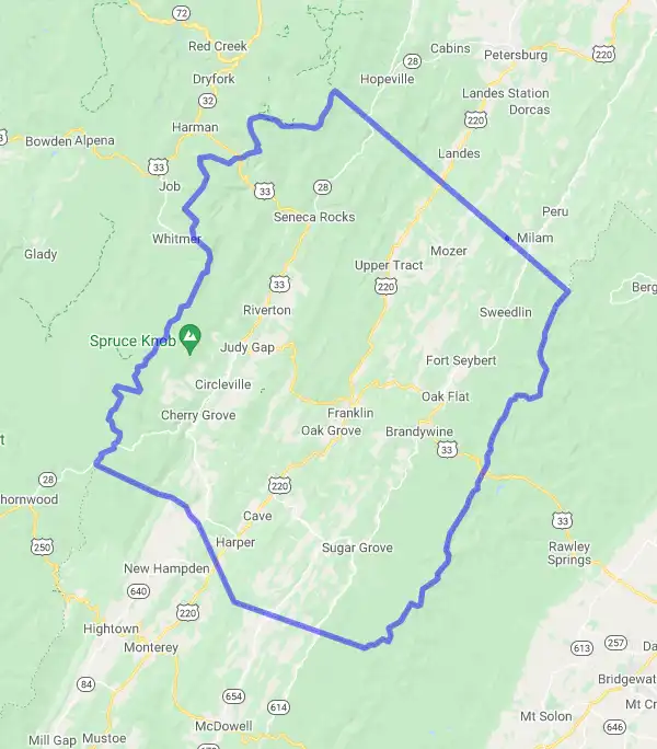
There are no geographical USDA loan restrictions in this county. 100% of Pendleton County is eligible for rural development USDA home loans.
The United States Department of Agriculture has rated the natural amenities of this region. On a scale of one to seven, Pendleton county is rated a 4. The average temperature during the month of June is 67.6℉ and the average temperature in January is 28.6℉. The typical humidity of this area is approximately 65% and the area covered by water is 0.03%. The overall influence score for Pendleton is 9.
The map below displays geographic boundaries of Pendleton, West Virginia with a blue border. There are no significant USDA regional restrictions in this county. For higher resolution imagery click the map to zoom in or search for specific postal (zip) codes, city names or even counties. You can also search for specific addresses using the power search feature here.
Select from the above list of cities in Pendleton County. Cities most likely to have USDA loan eligible properties are highlighted in the drop down list. Alternatively, use the search form to find your favorite counties, cities and zip codes in West Virginia.

Pendleton County is located in the Eastern Panhandle of West Virginia and borders both Virginia and Maryland. As of the 2010 census, the population of Pendleton County was 7,695. The racial makeup of the county was 97.4% White, 0.7% Black or African American, 0.4% Native American, 0.2% Asian, 0.1% Pacific Islander, 0.3% from other races, and 1.0% from two or more races.
The median income for a household in Pendleton County was $32,015, and the median income for a family was $38,169. The per capita income for the county was $17,742. About 12.3% of families and 15.6% of the population were below the poverty line.
Pendleton County consists mostly of rural farmland and forested areas with some residential development near towns like Circleville and Franklin along US 220 which bisects the county from north to south and US 33 which runs east to west across it. The county is served by two school districts: Pendleton County Schools and East Hardy County Schools which offer K-12 education services to residents in their respective regions.
Overall, Pendleton County has seen some economic growth in recent years as new businesses have begun to settle in the area due to its proximity to larger cities like Winchester, VA and Washington D.C.. Despite this growth however, many residents still face economic hardship due to low wages and a lack of job opportunities in the region.
Pendleton, West Virginia

Loan officers and realtors can answer your questions about USDA home loan programs.
For direct assistance with West Virginia USDA program details you can also contact:
USDA Rural Development programs are delivered through eleven offices in West Virginia. For more information, please contact the specific program area or the office nearest to you.Featured Property from USDA Loan Eligible Regions of West Virginia
State Office
1550 Earl Core Road, Suite 101
Morgantown, WV 26505
(304) 284-4860 | (855) 859-1834 fax

