Loading Data
Find USDA Eligible Properties in Breathitt County

 browse list of realtors working in Breathitt County
Hey, are you a realtor interested in helping families find USDA eligible properties in Breathitt County?
Join the USDAProperties Realtor Network
Looking to buy in Breathitt County, Kentucky?
Select from the list of cities below or use the search feature to find active property listings in a city where you would like to live.
Start your search for USDA loan eligible properties in the cities of Breathitt County, KY 
* cities most likely to have USDA loan eligible properties for sale.
Altro • Barwick • Bays • Beech • Canoe • Chenowee • Clayhole • Copebranch • Crockettsville • Elkatawa • Evanston • Fivemile • Flintville • Frozen Creek • Guage • Guerrant • Haddix • Hardshell • Houston • Hurst • *Jackson • Jetts Creek • Keck • Kragon • Lambric • Lawson • Little • Lost Creek • Lunah • Moct • Morris Fork • Mountain Valley • Ned • Noble • Noctor • Panhandle • Paxton • Portsmouth • Press • Quicksand • Rock Lick • Roosevelt • Rousseau • Sebastians Branch • Sewell • Shoulderblade • Simpson • Stevenson • Talbert • Taulbee • Turkey • Vancleve • War Creek • Watts • Wells Fork • Whick • Widecreek • Wilhurst • Wilstacy • Wolf Coal • Wolverine
A USDA loan is a mortgage option available to eligible homebuyers that is sponsored by the United States Department of Agriculture to promote homeownership in rural communities. USDA Loans, sometimes called "RD Loans," offer 100% financing options on eligible rural properties. USDAProperties can help you find USDA properties in Breathitt County.
View the detailed USDA boundaries and read about general conditions of
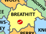
Breathitt County, Kentucky
 .
.Breathitt County, located in the great state of Kentucky, was established on February 8, 1839. The county was named in honor of Governor John Breathitt, who served as Kentucky's governor from 1832 to 1834. It is situated in the eastern region of Kentucky, covering an area of approximately 495 square miles.
Breathitt County's history is rooted in the coal and timber industries, with coal mining playing a prominent role in shaping the economy and lives of the local population. The county was also a key player in the Eastern Kentucky Coal Field, which was a principal source of income for families in the area.
One fun fact about Breathitt County is that it is often referred to as the "Land of Swinging Bridges." It has more swinging bridges than any other county in Kentucky, built originally to provide access between communities and homes when rivers and streams would render roads impassable. Many of these bridges are still in use today, offering a glimpse into the past and serving as a unique attraction for visitors to the region.
Featured Cities of Kentucky