Loading Data
Find USDA Eligible Properties in Garfield County
 browse list of realtors working in Garfield County
Hey, are you a realtor interested in helping families find USDA eligible properties in Garfield County?
Join the USDAProperties Realtor Network
Looking to buy in Garfield County, Montana?
There are 1 USDA backed residential loans in Garfield county with an average loan balance of $47,197. Over 100% of the loans helped first time home buyers. Borrowers were an average age of 26 years old. The typical appraised home value was around $48,000. On average the rural home size purchased with this loan was approximately 1,106 SqFt. Garfield county applies the standard USDA income limits to determine loan eligibility. For a household of upto 4 people the income limit is $90,300. For a household of between 5 and 8 people the income limit is increased to $119,200.
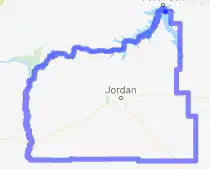
The size of Garfield County is roughly 12,550 square kilometers. There are no geographical USDA loan restrictions in this county. The influence score for Garfield County is 9. Look below for the interactive county level map illustration below for more details.
Select from the list of cities below or use the search feature to find active property listings in a city where you would like to live.
Start your search for USDA loan eligible properties in the cities of Garfield County, MT ![]()
* cities most likely to have USDA loan eligible properties for sale.
Benzien • Brusett • Cohagen • Edwards • Hillside • *Jordan • Mosby • Ross Hall • Sand Springs • Steve Forks
A USDA loan is a mortgage option available to eligible homebuyers that is sponsored by the United States Department of Agriculture to promote homeownership in rural communities. USDA Loans, sometimes called "RD Loans," offer 100% financing options on eligible rural properties. USDAProperties can help you find USDA properties in Garfield County.
View the detailed USDA boundaries and read about general conditions of
Garfield County, Montana
 .
.Garfield County is a county located in the great state of Montana, United States. Established on February 29, 1919, it was named in honor of James A. Garfield, the 20th President of the United States. The county has a total area of 4,847 square miles, making it the 19th largest county in Montana. Its county seat is Jordan, and the county was created from portions of Dawson and Prairie Counties.
The region has a rich history that dates back to the prehistoric times, with the presence of various native tribes such as the Plains Indians, Sioux, and Crow. These tribes inhabited the area long before European contact. In the late 19th century, European-American settlers began to arrive in the area, driven by the Montana gold rush and opportunities in ranching and farming.
One of the most significant archeological sites in Garfield County is the Hell Creek Formation, an area that has been extensively studied due to its abundant remains of dinosaur fossils. A fascinating fun fact about this region is that in 1990, a team led by paleontologist Jack Horner discovered the first fossil specimen of the T. rex ever found, which was named "Sue" in honor of its discoverer, Sue Hendrickson. This discovery has greatly contributed to our understanding of paleontology and the history of life on Earth.
Today, Garfield County remains predominantly rural, with the primary industries being agriculture, ranching, and oil production. The county is also recognized for its natural beauty, attracting visitors to its scenic landscapes for recreational activities such as hunting, fishing, and wildlife viewing.
Featured Cities of Montana


