Loading Data
Find USDA Eligible Properties in Prairie County
 browse list of realtors working in Prairie County
Hey, are you a realtor interested in helping families find USDA eligible properties in Prairie County?
Join the USDAProperties Realtor Network
Looking to buy in Prairie County, Montana?
There are 1 USDA backed residential loans in Prairie county with an average loan balance of $79,591. Over 100% of the loans helped first time home buyers. Borrowers were an average age of 24 years old. The typical appraised home value was around $81,000. On average the rural home size purchased with this loan was approximately 1,020 SqFt. Prairie county applies the standard USDA income limits to determine loan eligibility. For a household of upto 4 people the income limit is $90,300. For a household of between 5 and 8 people the income limit is increased to $119,200.
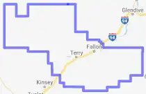
The size of Prairie County is roughly 4,514 square kilometers. There are no geographical USDA loan restrictions in this county. The influence score for Prairie County is 9. Look below for the interactive county level map illustration below for more details.
Select from the list of cities below or use the search feature to find active property listings in a city where you would like to live.
Start your search for USDA loan eligible properties in the cities of Prairie County, MT ![]()
* cities most likely to have USDA loan eligible properties for sale.
Benz • Blatchford • Bluffport • Calypso • Crow Rock • *Fallon • McCloud • Mildred • Saugus • *Terry • Zero
A USDA loan is a mortgage option available to eligible homebuyers that is sponsored by the United States Department of Agriculture to promote homeownership in rural communities. USDA Loans, sometimes called "RD Loans," offer 100% financing options on eligible rural properties. USDAProperties can help you find USDA properties in Prairie County.
View the detailed USDA boundaries and read about general conditions of
Prairie County, Montana
 .
.Prairie County, Montana, is a rural county established on February 5, 1915, carved out of portions from Custer, Dawson, and Fallon counties. Located in the east-central part of the state, the county has a rich historical background that dates back to the early days of European explorations in the area.
One of the key moments in Prairie County's history took place in the early 1810s when the first European explorers ventured into the area, searching for a suitable land route to the Pacific Ocean. That journey, known as the Lewis and Clark Expedition (1804-1806), led by Meriwether Lewis and William Clark, brought them close to the region, exposing the vast prairie landscape to a wider audience.
As settlers began moving westward in the mid-1800s, cattle ranching and cattle drives grew in prominence, creating a booming livestock economy in parts of the county. The arrival of the Northern Pacific Railway in Montana during the late 1800s played a significant role in the county's growth, providing transportation and attracting more settlers to the region.
Towns like Terry and Fallon are key communities in Prairie County. Terry, being the county seat, emerged as an important economic and social hub in the area, offering various services and amenities to residents and visitors alike.
One fun fact about Prairie County is that it is home to the Terry Badlands, a stunning geological area filled with eroded sandstone formations, vast grasslands, and deep ravines. This natural wonderland, accessible through a scenic backcountry byway, offers numerous opportunities for hiking, wildlife viewing, and photography, making it a great destination for outdoor enthusiasts.
Featured Cities of Montana


